Free Editable layered vector map of Boston Massachusetts US in Adobe Illustrator, PDF, SVG: You can use this map without any restrictions and limits.
FREE DOWNLOADS:
Adobe Illustrator Boston Map download now >>> 3,536 MB FREE
Adobe PDF Boston Map download now >>> 6,709 MB FREE
SVG Boston Map download now >>> 2,235 MB FREE
Also: See full versions of the Boston Maps
Boston Massachusetts US Free Vector Map in Adobe Illustrator, PDF, SVG
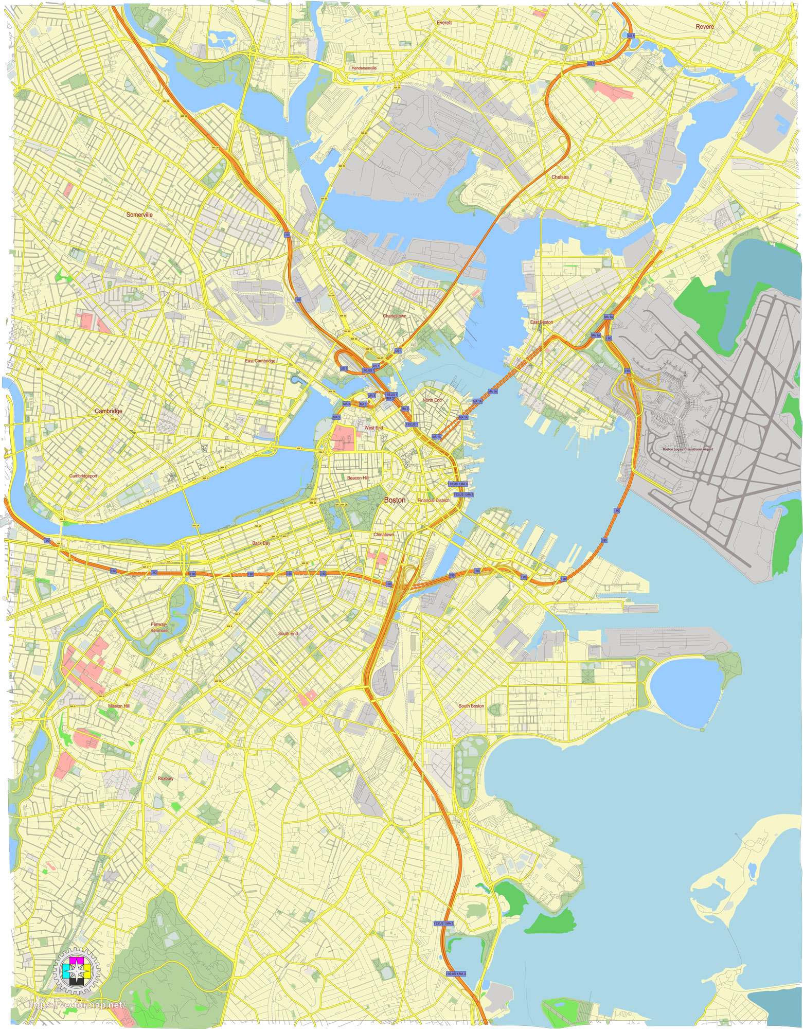
Boston is a city with a complex network of streets and roads, many of which have historical significance. Here’s a detailed description of some of the main streets and roads in Boston:
Main Streets and Roads in Boston
- Massachusetts Avenue (Mass Ave):
- A major thoroughfare running from Dorchester in the south, through the South End, Back Bay, and over the Charles River into Cambridge. It is lined with shops, restaurants, and educational institutions.
- Commonwealth Avenue:
- A grand boulevard in the Back Bay area, known for its wide, tree-lined central mall. It runs from the Public Garden in Boston’s downtown area westward through the Back Bay and out to the Boston University campus and beyond.
- Boylston Street:
- Runs parallel to Commonwealth Avenue and is another major street in the Back Bay. It’s home to numerous shops, restaurants, and cultural institutions, including the Boston Public Library and several theaters.
- Newbury Street:
- A famous shopping and dining destination, running parallel to Boylston Street in the Back Bay. It features a mix of high-end boutiques, galleries, cafes, and restaurants.
- Huntington Avenue:
- Often called the “Avenue of the Arts,” it is home to several cultural institutions, including the Boston Symphony Orchestra, Northeastern University, and the Museum of Fine Arts.
- Beacon Street:
- Runs from the Boston Common, through the Beacon Hill neighborhood, past the Massachusetts State House, and continues west through Brookline and into the suburbs. Known for its historic brownstones and scenic views.
- Tremont Street:
- Runs from downtown Boston through the South End. It passes by significant landmarks like the Boston Common, Boston Opera House, and several historic churches.
- Washington Street:
- A historic street that runs from Downtown Crossing through the South End and into the neighborhoods of Roxbury and Jamaica Plain. It has a mix of commercial and residential areas.
- Storrow Drive:
- A major parkway running along the Charles River, providing scenic views of the river and access to the Esplanade. It’s a key route for drivers traveling through the city.
- Memorial Drive:
- Running parallel to Storrow Drive on the Cambridge side of the Charles River, it offers beautiful views of the Boston skyline and is popular for recreational activities.
- Atlantic Avenue:
- Runs along the waterfront in downtown Boston, passing by the New England Aquarium, the Rose Kennedy Greenway, and the Boston Harbor.
- Summer Street:
- Connects South Boston to downtown, passing through the Seaport District, which has seen significant development with numerous restaurants, hotels, and the Boston Convention and Exhibition Center.
- Congress Street:
- Also runs through the Seaport District and downtown, crossing Fort Point Channel and providing access to key areas like the Boston Children’s Museum and the Boston Tea Party Ships and Museum.
- Charles Street:
- Runs between Beacon Hill and the Boston Common, known for its charming shops, cafes, and restaurants.
- Cambridge Street:
- Extends from Government Center and Beacon Hill out to the West End and into Cambridge, passing by Massachusetts General Hospital and the Charles River.
- Blue Hill Avenue:
- A major arterial road running through Roxbury, Dorchester, and Mattapan. It is an important corridor for Boston’s African American community and hosts a variety of local businesses and institutions.
Summary
Boston’s main streets and roads reflect its rich history and diverse neighborhoods. Streets like Commonwealth Avenue, Boylston Street, and Newbury Street are central to the city’s commercial and cultural life, while routes like Storrow Drive and Memorial Drive offer scenic views and important commuter paths. Each street has its own unique character and significance, contributing to the vibrant tapestry of Boston’s urban landscape.
 Author: Kirill Shrayber, Ph.D. FRGS