Editable Vector Map of the Basel Switzerland in SVG format.
Can be edited in the following programs: Adobe Illustrator, CorelDraw, InkScape
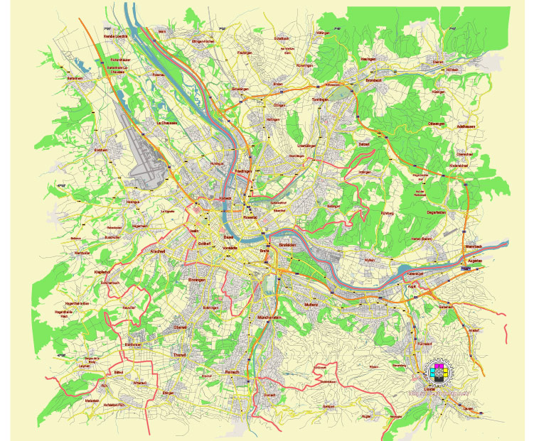
Principal streets and roads, names places, residential streets and roads, road number labels, water objects, land use areas.
Basel Switzerland editable vector map svg free
DOWNLOAD ARCHIVE FOR FREE >>>
Distributed with Creative Commons Attribution 4.0 International License
SEE ALSO FULL VERSION OF THE Basel Switzerland vector map (Adobe Illustrator, PDF etc.)
Basel, Switzerland, is a vibrant city with a rich history, located at the meeting point of Switzerland, Germany, and France. Here are some of the principal streets, roads, and city districts of Basel:
Principal Streets and Roads
- Freie Strasse:
- This is one of the main shopping streets in Basel, known for its high-end stores and boutiques. It’s located in the city center and is a pedestrian-only zone.
- Steinenberg:
- Another important street in Basel, home to theaters, restaurants, and cafes. It connects the Theater Basel to the city center.
- Aeschenplatz:
- A major traffic junction and tram hub in Basel. It’s a key connecting point for various tram lines and has a mix of offices, shops, and restaurants.
- Claraplatz:
- Located in Kleinbasel (the smaller part of Basel on the right bank of the Rhine), Claraplatz is another significant commercial area with numerous shops and eateries.
- St. Alban-Graben:
- This street is known for its cultural significance, housing important institutions such as the Kunstmuseum Basel (Museum of Art).
- Elisabethenstrasse:
- Close to the city center, this street is notable for its proximity to the Basel SBB railway station and the Elisabethenkirche (Church of St. Elizabeth).
- Mittlere Brücke:
- One of the main bridges over the Rhine, connecting Grossbasel (Greater Basel) and Kleinbasel. It’s a historical bridge and a key route for both pedestrians and vehicles.
Principal City Districts
- Grossbasel (Greater Basel):
- Located on the south bank of the Rhine, it encompasses the old town (Altstadt Grossbasel) with its medieval architecture, the Basel Minster (cathedral), and many museums. This district is the historical and cultural heart of the city.
- Kleinbasel (Lesser Basel):
- Situated on the north bank of the Rhine, this area is known for its vibrant nightlife, diverse communities, and the bustling Claraplatz. It includes the old town (Altstadt Kleinbasel) of this part of the city.
- St. Alban:
- Known as the “District of the Rich and the Beautiful,” this area features picturesque streets, historical buildings, and the scenic St. Alban Tal along the Rhine.
- Gundeldingen:
- Located south of the Basel SBB railway station, Gundeldingen is a residential area with a mix of old and new buildings, and it has a diverse population.
- Breite:
- Situated southeast of the city center, Breite is a mainly residential area known for its green spaces and family-friendly environment.
- St. Johann:
- Located in the northwest of Basel, near the French border, this district has a mix of residential and industrial areas, as well as the Novartis Campus.
- Wettstein:
- Found on the east side of the Rhine, this district includes the Messe Basel exhibition center and is home to many modern office buildings and residential areas.
These streets and districts are essential for understanding Basel’s layout and cultural landscape. Whether you’re interested in shopping, history, or local life, each area offers unique experiences and insights into the city’s character.
 Author: Kirill Shrayber, Ph.D. FRGS