Editable Vector Map of the Baku Azerbaijan in SVG format.
Can be edited in the following programs: Adobe Illustrator, CorelDraw, InkScape
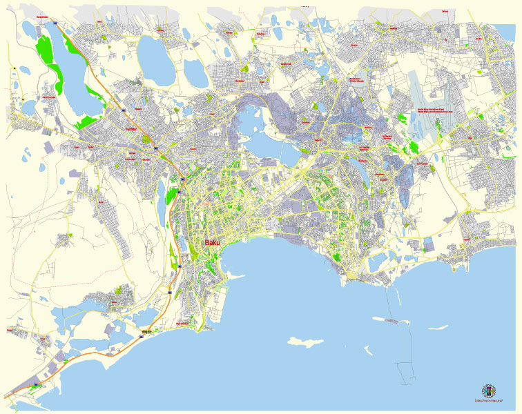
Principal streets and roads, names places, residential streets and roads, road number labels, water objects, land use areas.
Baku Azerbaijan editable vector map svg free
DOWNLOAD ARCHIVE FOR FREE >>>
Distributed with Creative Commons Attribution 4.0 International License
SEE ALSO FULL VERSION OF THE Baku Azerbaijan vector map (Adobe Illustrator, PDF etc.)
Baku, the capital of Azerbaijan, is a vibrant city with a blend of modern architecture, historical sites, and a bustling urban atmosphere. Here are some of the principal streets, roads, and city districts in Baku:
Principal Streets and Roads
- Neftchilar Avenue: This major thoroughfare runs along the Caspian Sea and connects the Old City with modern districts. It’s a key route for accessing many of Baku’s landmarks and is known for its scenic views.
- Heydar Aliyev Avenue: Named after the former president, this wide avenue is an important connector within the city, leading to the Heydar Aliyev Center, one of Baku’s most iconic modern buildings.
- Tbilisi Avenue: This road is a significant arterial route, providing access to the northwestern parts of the city and connecting with key highways leading out of Baku.
- Azadliq Avenue: A central avenue in Baku, it hosts various governmental buildings, businesses, and is known for its vibrant atmosphere.
- Nizami Street (Torgovaya): This pedestrian street is a major shopping and entertainment area, lined with boutiques, cafes, and cultural spots.
- Baku Boulevard (Seaside National Park): Not exactly a road, but a long promenade along the Caspian Sea, popular for leisurely walks, entertainment, and offering beautiful views of the city skyline.
Principal City Districts
- Icherisheher (Old City): The historic core of Baku, a UNESCO World Heritage Site, featuring ancient buildings, narrow streets, the Maiden Tower, and the Palace of the Shirvanshahs.
- Nasimi District: Named after the poet Imadaddin Nasimi, this district is central and houses many administrative buildings, educational institutions, and cultural centers.
- Nizami District: Known for residential areas and cultural sites, including the famous Nizami Museum of Azerbaijani Literature.
- Sabail District: Includes parts of Baku’s coast and the Old City. It’s known for its blend of historical and modern architecture, embassies, and luxury residences.
- Yasamal District: A residential area with several parks and educational institutions, known for its mix of Soviet-era buildings and new developments.
- Binagadi District: A largely residential district with growing commercial activity and new infrastructure developments.
- Khatai District: A commercial and residential area that includes the Heydar Aliyev Center and several shopping malls.
- Surakhani District: Located in the eastern part of Baku, known for its industrial areas and oil-related history, including the Ateshgah Fire Temple.
- Garadagh District: Known for its industrial facilities and proximity to the Baku Port, playing a crucial role in the city’s economy.
These streets, roads, and districts collectively shape the character and functionality of Baku, making it a dynamic and diverse city.
 Author: Kirill Shrayber, Ph.D. FRGS