Editable Vector Map of the Albany New York US in SVG format.
Can be edited in the following programs: Adobe Illustrator, CorelDraw, Inkscape
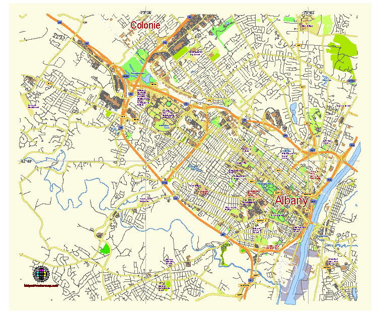
Principal streets and roads, names places, residential streets and roads, road number labels, water objects, landuse areas.
Albany New York US editable vector map svg free
DOWNLOAD ARCHIVE FOR FREE >>>
Distributed with Creative Commons Attribution 4.0 International License
SEE ALSO FULL VERSION OF THE Albany New York US vector map (Adobe Illustrator, PDF etc.)
Albany, the capital of New York State, is a city rich in history and culture, featuring several notable streets, roads, and districts. Here is an overview:
Principal Streets and Roads
- State Street: One of Albany’s most important thoroughfares, State Street runs from the Hudson River waterfront up through the city, passing by key landmarks such as the New York State Capitol and the Empire State Plaza.
- Central Avenue: A major commercial street that runs west from downtown Albany through the city’s Pine Hills neighborhood and into the suburbs. It is part of U.S. Route 20.
- Washington Avenue: Another crucial road in Albany, it starts near the downtown area, running westward past the State University of New York (SUNY) Albany campus.
- Western Avenue: A significant arterial road running from downtown Albany through the western neighborhoods, providing access to the SUNY Albany uptown campus and the surrounding suburbs.
- Madison Avenue: This avenue runs parallel to Washington Avenue and passes through several residential and commercial districts, including the Pine Hills neighborhood.
- Broadway: Running north-south, Broadway is a major street in downtown Albany, close to the riverfront and numerous historic sites.
Key City Districts
- Downtown Albany: The central business district, home to government buildings, the Times Union Center, cultural venues like The Egg, and a variety of restaurants and shops.
- Arbor Hill: One of the oldest neighborhoods in Albany, known for its historic architecture and diverse community.
- Pine Hills: A residential neighborhood with a mix of students, families, and professionals. It is known for its lively commercial district along Madison and Western Avenues.
- Center Square/Hudson Park: A vibrant area known for its historic brownstones, close to Washington Park. It has a strong community vibe and hosts several annual festivals.
- Mansion District: Located near the Empire State Plaza, this district features historic mansions and is a hub for Albany’s preservation efforts.
- West Hill: Primarily residential, West Hill has a mix of housing styles and is undergoing various community revitalization projects.
- South End: An area with a rich history and a mix of residential and industrial zones. It is experiencing ongoing redevelopment efforts.
- Delaware Avenue: Known for its commercial corridor and residential areas, the Delaware Avenue neighborhood is a mix of suburban and urban living.
- North Albany: A neighborhood with a mix of industrial, commercial, and residential properties, located north of downtown Albany.
These streets and districts contribute to the character and functionality of Albany, making it a dynamic and multifaceted city.
 Author: Kirill Shrayber, Ph.D. FRGS