Urban plan Jerusalem Israel ai pdf dwg dxf
Gallery of Images "Urban plan Jerusalem Israel ai":
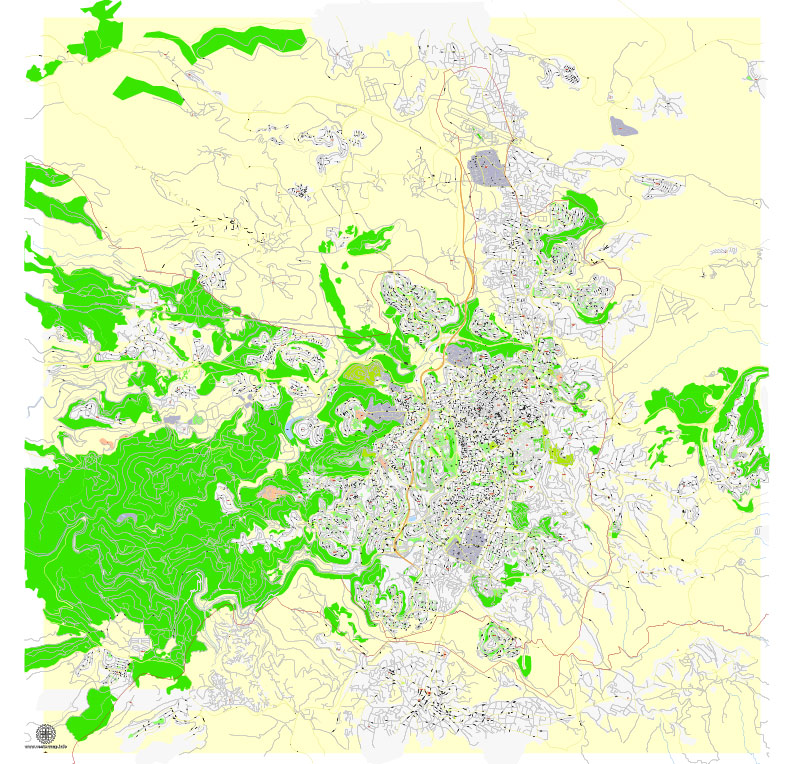
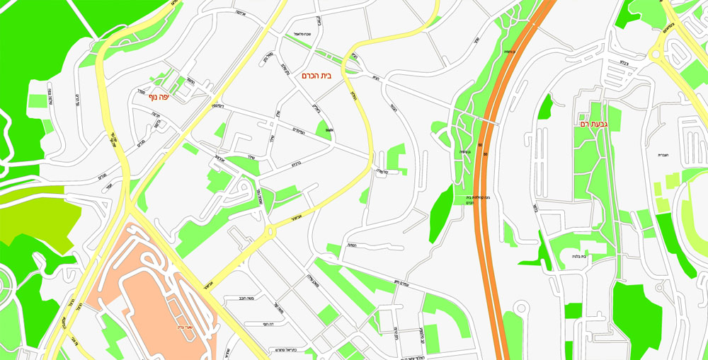
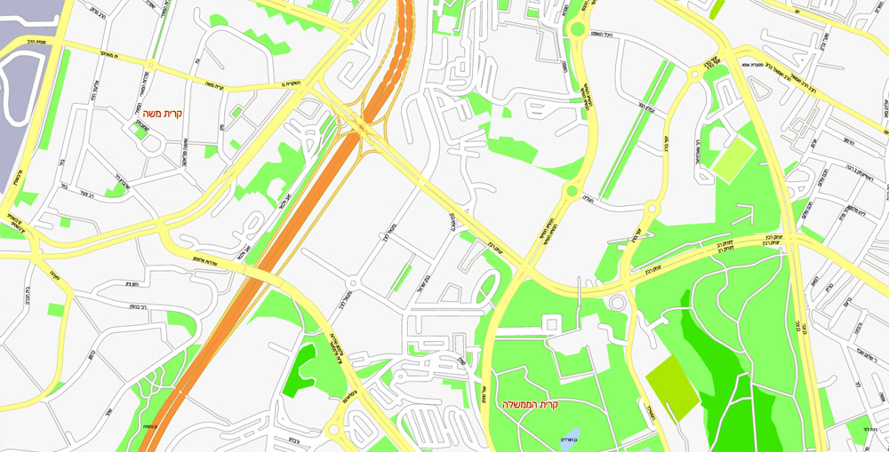
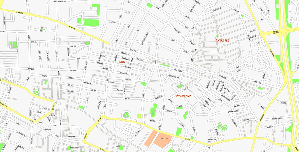
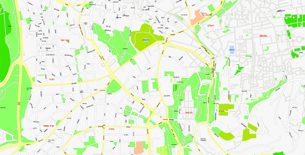
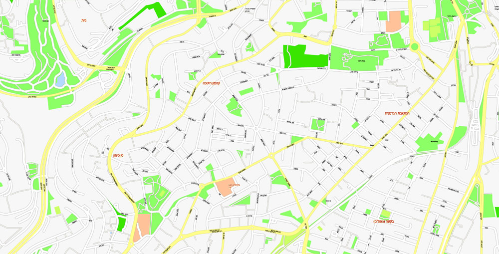
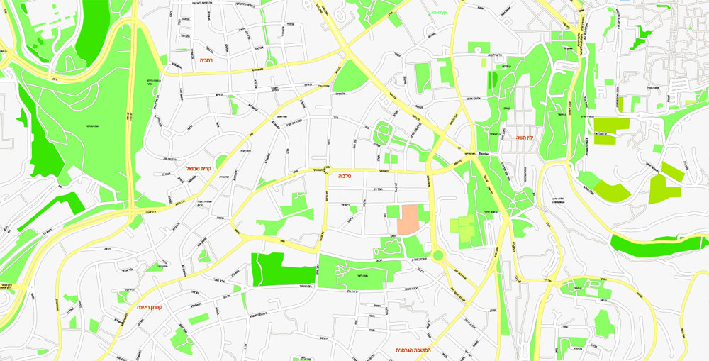
Urban plan Jerusalem Israel: Digital Cartography for Research, Business, Education
Jerusalem, Israel: Location
The capital of the State of Israel - the ancient city of Jerusalem is located 65 kilometers from the Ben-Gurion airport in Tel Aviv.
Jerusalem is located at an altitude of 650-840 meters above sea level and occupies the territory between the Mediterranean and the Dead Sea.
The landscape of Jerusalem is decorated with peaks such as Mount Scopus (height 829 meters), Mount Herzl (834 meters), Mount Romema (830 meters), and Mount of Olives (807 meters). In the suburbs, there are mountains: Ora (848 meters), Gilo (923 meters), Shmuel ha-Navi (855 meters).
The territory of the city occupies 108 square kilometers.
Jerusalem Time zone: GMT+2
Climate
Jerusalem is located in a mountainous subtropical climatic zone. In summer, it is usually hot and dry here, and in winter it is quite cold, during this period the main amount of precipitation falls in the form of rain.
Snow in Jerusalem falls infrequently and melts quickly (during the day).
The average daytime temperature in the summer months is +24°C, and from December to February, the average temperature is +9°C.
The maximum air temperature recorded in this area in summer is +41°C, and the minimum (in winter) is -5°C.
The air humidity (average annual) is 62%.
Jerusalem is located in the Judean Mountains between the Mediterranean and the Dead Sea at altitudes of 650-840 m above sea level.
Jerusalem is divided into 2 ethnopolitical districts: western Jewish and eastern Arab.
Date of foundation: XX-XIX centuries BC - the first mentions in ancient Egyptian sources; the first archaeological finds on the Temple Mount date back to IV-V thousand BC.
Historical names:
XIX-XIV centuries BC: the first mention of Jerusalem in the form of Rušalimum/ Urušalimum is contained in the Egyptian spells of the time of the XII dynasty against hostile cities; under the Akkadian name Urusalim, the city is mentioned in the Tel Amarna tablets of the XIV century BC.
XI century BC-130: Jerusalem, - probably the original name of the city was Irushalem (iarah — "to found" and Shalim / Shulman - the name of the West Semitic deity who was the patron saint of the city) - "the foundation of Shalim". In the Midrash, the name of the city is usually associated with the word shalom (Hebrew) - "peace". The Greek name of the city ἹΕροσλΛυμα, derived from Hebrew, is associated with the sanctity of the city (Greek: ιερός - "holy")2.
II thousand BC, the second half: Shalem (ללל Hebrew) - "peace" - the name of the city of the Canaanites in Genesis (14:18), before the conquest of the country by the Israelites.3
XI century BC: Zion is the fortress of the Jebusites, renamed by the king of David (c. 1005 - 965 BC) after the conquest in 1002 BC, into the "City of David" (2 Kings 5:9).
130-4384/ 638: Aelia Capitolina (Latin) is the name of a Roman colony in honor of Emperor P. Aelius Hadrian (117-138) and Jupiter Capitoline.
638-1099: al-Quds - (اللددس Arabic, "sanctuary") or Bet-al-Makadis (the place of the sanctuary), the early Arab authors also used the Latin name Aeolia in the form of Elijah (للياا Arabic, ĪLyā). The name "al-Quds" is still used by the Arab population today.
1099-present: Jerusalem.
II thousand BC: the city of the Semitic Canaanites from the tribe of Jebusites with an area of 3 hectares was located in the southeast of modern Jerusalem. In the 2nd half of the II millennium BC - under the control of Egypt.
1002-928 BC: The United Kingdom of Israel.
928-586 BC: The Kingdom of Judea.
538-167 BC: A self-governing Jewish temple community within the Persian Achaemenid empire (538-332 BC), the state of Alexander the Great (332-323 BC), the Ptolemaic kingdoms (321-198 BC) and the Seleucids (198-167 BC).
164-37 BC: the Judean kingdom of the Hasmoneans (Maccabees) and in 40-4 BC and 41-100 - Judea of the Herod dynasty, from 63 BC under the Roman protectorate.
1099, July 15-1187: The Crusader Kingdom of Jerusalem.
1517-1864: The regional city of the Damascus Vilayet (governorate-general) in Syria in the Turkish Empire, was the center of a separate sanjak in 1683-1864.
1864-1917, December 11: Separate Jerusalem Province (Mutasarrifiyet) of the Turkish Empire.
1920, July 1-1948, May 15: British mandate over Palestine.
1949, January 13-1967, June 11 - the western part of Jerusalem is the capital of the State of Israel.
1967, July 28-present: all of Jerusalem is the capital of the State of Israel; on July 30, 1980, the city was declared the "one and indivisible" capital of the State of Israel.
The central State bodies of the State of Israel are located in Jerusalem:
President.
Government.
The Parliament is the Knesset.
Geographical coordinates: 31º47c.w., 35º13c.d.
Population: 763.8 thousand people
Area: 652 km2
Attractions
Walls and gates of the Old City
Built-in the XVI century by the Turkish Sultan Suleiman the First. During the construction, the material of the more ancient structures of the city was partially used.
1. The Damascus Gate. is called in Hebrew "Shaar Shechem" (Shechem Gate). In Arabic, "Bab el Amud" (the gate of the Pillar). Located in the northern part of the Old Town. These gates are the main entrance to the Muslim quarter.
2. New gates. Fully justify their name. They were pierced through the walls in 1889 at the request of the French consul to facilitate communication of the Christian Quarter with the new districts of Jerusalem.
3. The Jaffa Gate.
4. The Zion Gate.
5. Manure gates.
6. Lion Gate.
7. Herod's Gate.
The Temple Mount is the oldest sacred place in Israel and one of the three main attractions of the Old City. It is located inside the Muslim quarter, but due to the peculiarities of Palestinian-Israeli relations, access to it is possible only through a specially built bridge and a border control point (do not forget your passport) located near the Garbage Gate. Getting out of the square is much easier: any open gate will take you to the streets of the Muslim quarter. The dress code for visitors prescribes modest attire, with legs up to the knees and arms up to the elbow should be covered. If there is no suitable equipment, then you can rent a cape for an additional fee. However, the form of clothing is controlled only at the entrance, then no one is interested in the appearance of tourists.
8. The Temple Mount (Haram esh-Sharif). In summer: Mon-Sun 7:30 - 11:00, Mon-Sun 13:30 - 14:30, in winter: Mon-Sun 7:30 - 10:00, Mon-Sun 12:30 - 13:30, lunch hours are very crowded. Admission is free. In fact, it is a rectangular square towering over the Old City, where the First (X-VI century BC) and Second (IV century BC – 70 AD) Jerusalem Temples once stood. Ancient prophecies claim that a Third Temple will be built here someday. The square is surrounded by a wall of different ages, its oldest preserved sections were erected by Herod the Great during the time of the Second Temple. The most famous section of Herod's Wall is the Wailing Wall or the Western Wall.
9. The Dome of the Rock. is one of the oldest and most beautiful mosques in the world, located in the center of the Temple Mount. The mosque was built in the VII century over the Cornerstone of the universe - the Rock from which, according to the Jews, the Creation of the World was begun. For the Jews, this place is sacred: they believe that the sacrifice of Isaac was to be performed on this Rock, and after the construction of the Temple, the Ark of the Covenant was kept on it. Muslims do not lag behind and claim that the miraj (ascension to the Lord) of the Prophet Muhammad happened just from this Rock. Few people are allowed to see the shrine: not only are only Muslims allowed inside, but even they will need special permission to approach the Rock. The first version of the mosque was built during the time of Caliph Abd al-Malik in 687-691, and it acquired its current appearance in the XI century during restoration work after another earthquake. At the time of the Crusaders, the mosque was turned into a church, but by the end of the XII century, everything was back to normal. The building was built according to strict geometric laws: the lower part has the shape of a regular octagon, the side of which is exactly equal to the diameter of the dome. The dome was placed on a low drum and had a copper coating almost all its "life", but it received gilding only in the XX century. The rock in the center of the mosque is surrounded by an octagonal arcade, on which the dome rests, its interior decoration in the form of complex floral ornaments and inscriptions is mind-blowing. Along the outer wall there is a second contour of the arcade, decorated with mosaics and inscriptions of the end of the VII century. Both arcades together with the outer wall form a pair of covered galleries, one more delightful than the other. Non-Muslim tourists are not destined to see the inner splendor and will have to limit themselves to contemplating the exterior cladding, which is an exact copy of the Persian tiles used in 1545 by Suleiman the Magnificent to restore the original mosaic.
Mavaziny (libra). Eight flights of stairs, ending in narrow porticos, lead to the Dome of the Rock standing on the platform. These are kanatiras or mawazins, on which, according to the beliefs of Muslims, scales for weighing souls will be fixed on the day of God's Judgment. All mavazines are different: they differ in style, construction time, and the number of spans.
10. The Dome of The Chain.On the central platform of the Temple Mount, in addition to the main dome, there are a dozen other domes. The most remarkable of them is the dome of the Chain, lined with magnificent ceramics of the XIII century. Its purpose is not exactly known, there is a version that it could be used as a treasury. The chain mentioned in the name of the dome, according to legend, once hung from its roof and was used as a kind of lie detector: to tell a lie while holding on to it meant immediate death from a lightning strike.
11. Al-Aqsa Mosque. is the third most important shrine of Islam after the mosques in Mecca and Medina. It is about twenty years younger than the Dome of the Rock, but, unlike the latter, its original interior was almost lost after several devastating earthquakes. At the beginning of the XI century, the mosque was significantly rebuilt and did not change much after that. A small contribution to its appearance was made by the Knights Templar, who left three central spans of the main facade as a souvenir, a couple more spans on each side were added in the XIV century by the Mamluks. The interior design was changed repeatedly and supplemented even in the XX century: marble columns were donated by Benito Mussolini, and the ceiling was painted at the expense of the Egyptian King Farouk I. If you manage to get inside, do not miss the more ancient details of the interior - the mihrab of 1187 and the mosaic decoration of the arch of the central passage.

12. Madrasah complex. The western and northern sides of the square are bounded by a complex of madrasahs of the XIV-XV centuries. On the west side under the madrasah is a long and spectacular colonnade from 1330, reminiscent of the ancient colonnade of the Second Temple. Five gates are hidden in the bowels of this colonnade. The most spectacular structure on the western side, the Ashrafiyya Madrasah, was built in 1482 and is considered a masterpiece of Islamic architecture, including thanks to the ornament of colored stone adorning the entrance door. A pair of madrasahs on the north side was built in the XIV century looks somewhat more modest.
13. Golden Gate (Gate of Mercy). Looking at the Mount of Olives, the eastern side looks more like a small square and is practically not built up. The most important thing here is the laid Golden Gate, which must be viewed from the outside, from the side of the Muslim cemetery broken at their foot. They were built in the time of Herod the Great, and then rebuilt in the time of the Umayyads. Their fame is connected with the Messiah, who, according to an ancient prophecy, will enter Jerusalem through them. It is rumored that because of fears of the prophecy, Muslims laid the gates in the XVI century. The gate itself consists of two parts, and each has had its own name since ancient times: the outer gate of Mercy, the inner gate of Repentance. The modern name originated in the time of the Crusaders due to a translation error.
14. Fountains. Between the madrasah complexes and the main platform there are several small structures - fountains or mausoleums. The Katbey Fountain (the end of the XV century) stands out with a dome with magnificent stone carvings, and the oldest and most unusual of the fountains of El-Kas is located between the Dome of the Rock and the Al-Aqsa Mosque. It was carved from a solid stone block in 1320 and is still functioning.
15. Minarets. Four minarets have been preserved on the Temple Mount, and all of them are of a very venerable age. The Al-Pahariya minaret, standing in the southwest corner, was built in 1278. The minaret above the Chain Gate, located on the western side of the complex, appeared in 1329 under Emir Tankiz. The al-Ghawanim Minaret, built in 1297 by the Mamluk Sultan Husam ed-Din Matshun, rises above the north-western corner of the Temple Mount. And finally, the minaret of the Tribes of Israel in the northeast side was erected in 1367 on the foundation of a former similar structure. It is the only one of the four, made in the Syrian style and has a cylindrical trunk.
16. Gates. In total, the Temple Mount has 11 gates: seven are located on the west side, three gates are in the north, plus a closed Golden Gate from the east. At the time of the Second Temple, there was also a Hulda gate from the south, intended only for Jews and served as the main entrance at that time, the remains of this gate can be seen from the south side of the Temple Mount. Located to the west, a small Moorish gate is used only to enter the Temple Mount. Two more gates are distinguished by a massive two-part structure. These are the Chain Gates located at the western wall and the eastern Golden Gate mentioned above. Among the remaining small gates, the most spectacular is the gate of the Cotton Market with an ornate portal from the time of the Mamluks (1337).
17. Via Dolorosa.
18. The Western Wall (The Wailing Wall).
19. The Tower of David.
20. The Church of the Holy Sepulchre.
21. The Holy Sepulchre
22. Golgotha.
23. Mount of Olives (Mount of Olives).
24. The City of David.
25. Mount Zion.
26. The tomb of King David.
27. King Solomon's quarries (Zedekiah's Cave).
28. The Monastery of the Holy Cross.
29. Mount Herzl and the Theodor Herzl Museum.
30. Nakhlaot Historical District.
31. Abandoned Arab Elevator village with swimming pool and spring
Related Images "Urban plan Jerusalem Israel ai":
Jerusalem Israel Vector Maps for Design, Printing, Business, Education

Jerusalem Israel Vector City Maps - AI Architecture Urban Design
Architecture plans of Jerusalem Israel: AutoCAD Digital Cartography
Jerusalem Israel Maps for Design and Printing
- Urban plan Bucharest Romania ai
- Urban plan Liege Belgium pdf
- Urban plan Lexington Kentucky 3 10
- Urban plan Poznan Poland pdf
- Urban plan Texas Louisiana Counties PDF
- Urban plan Spanish Town Jamaica
- Urban plan Syria
- Urban plan Montreal Grande area Canada
- Urban plan Kansas City Missoury 3 10
- Urban plan Greensboro North Carolina
- Urban plan Fargo North Dakota
- Urban plan Chicago Illinois ai
- Urban plan Santa Fe New Mexico PDF
- Urban plan Izhevsk Russia
- Urban plan Tomsk pdf
- Urban plan Hartford Connecticut PDF
- Urban plan Madison Wisconsin PDF
- Urban plan Lahore Pakistan PDF
- Urban plan Istanbul Turkey ai
- Urban plan Pakistan Full
- Urban plan Quebec City Canada 13 PDF
- Urban plan Travis County Austin Texas PDF
- Urban plan Canberra Australia PDF
- Urban plan Ireland Admin
- Urban plan Saratov pdf
- Urban plan Manhattan New York City
- Urban plan Macau China 125 PDF
- Urban plan Pyrenees Relief Roads
- Urban plan London Greater UK 13
- Urban plan Reykjavik Iceland PDF
- Urban plan Albuquerque Rio Rancho New Mexico SVG
- Urban plan Milano Italy
- Urban plan Boston
- Urban plan Wellington New Zealand 3 11
- Urban plan Italy Admin
- Urban plan Rouen Metro France PDF
- Urban plan Krasnoyarsk Russia
- Urban plan Austria Roads
- Urban plan San Diego Tijuana California
- Urban plan Shenzhen China 17 AI ENG
- Urban plan Liege Belgium AI 13
- Urban plan Riga Latvia ai
- Urban plan Reno Nevada PDF
- Urban plan Mykonos Island
- Urban plan Flagstaff Arizona
- Urban plan Reykjavik Iceland PDF
- Urban plan Hobart Tasmania PDF
- Urban plan Beijing China PDF 13
- Urban plan Oakland Berkeley Richmond Alameda San Leandro Albany California PDF
- Urban plan Barnstable Massachusetts
- Urban plan Prague 25