Urban plan Athens Pireas Greece Vector Map PDF ENG
Video "Urban plan Athens Pireas Greece ENG":
Gallery of Images "Urban plan Athens Pireas Greece ENG:
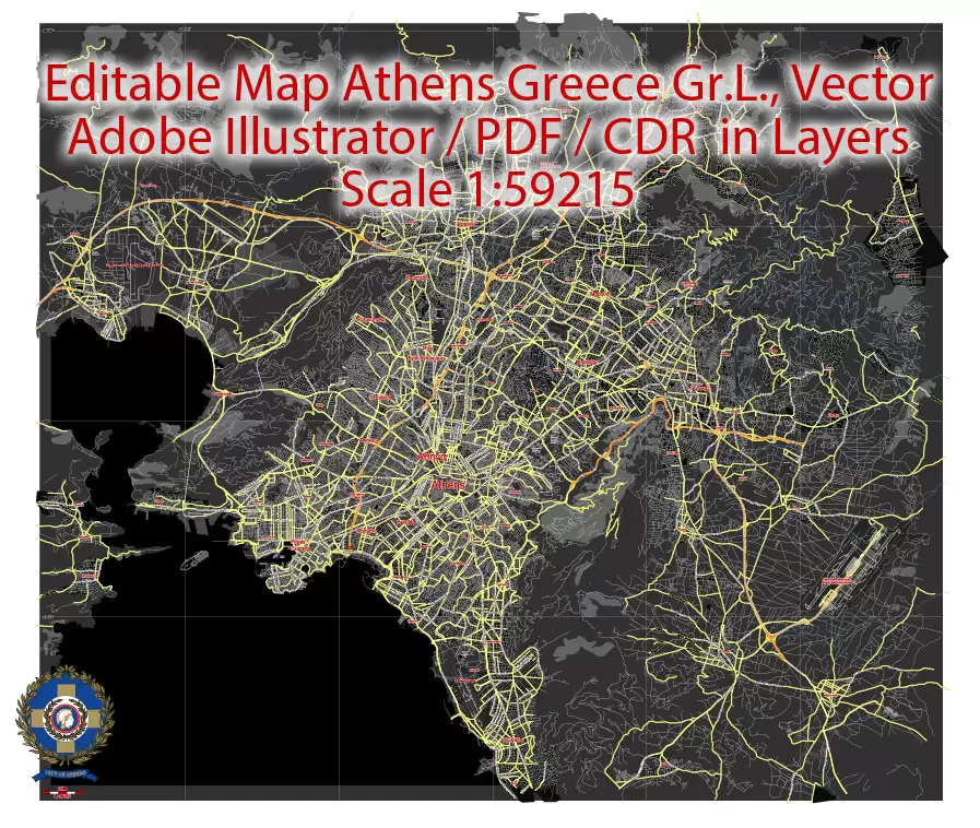
Athens Pireas Printable PDF Vector Map, Greece, exact


Athens Pireas Printable Map, Greece, exact vector street


Urban plan Athens Pireas Greece ENG
Athens is not just a capital city. It was here that classical Greece was born, and hence Western civilization in general. The first prehistoric settlement arose here around 3000 BC. For many centuries, everything happened to Athens, including periods of decline. It's hard to imagine, but in the 1830s, when the city began to revive after Ottoman oppression as the capital of independent Greece, Athens was just a small provincial village.
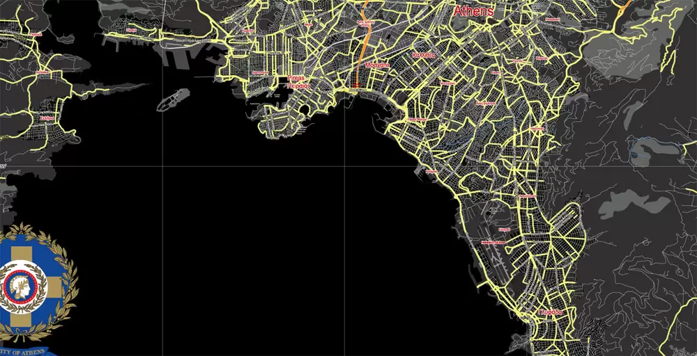
Athens includes the Old City, central districts, suburbs, as well as the port of Piraeus. Two hills rise in the center: the Acropolis hill with the Parthenon and ancient temples and the Lycabettus hill with the picturesque church of St. George on top.
In Athens, you can spend a month exploring in detail all the ancient monuments and ruins, charming neoclassical buildings in the historical center and museums. But if you really decide to do this, keep in mind that even in the very center of the city there are places where you should not go without doing anything. Seriously: the Omonia quarter, filled with emigrants, is best avoided even in the bright light of day.
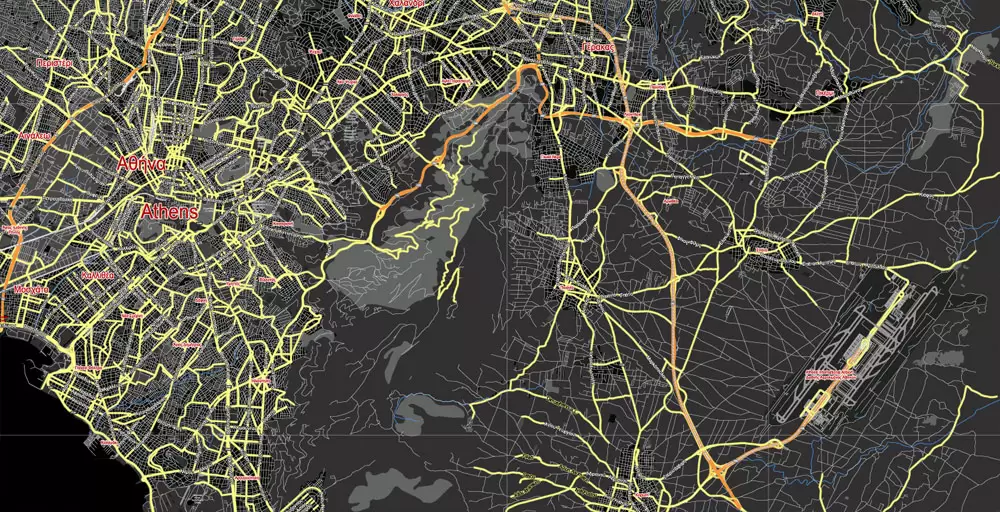
Districts of Athens
The Greek capital is divided into 7 districts and several dozen blocks and districts. Some of them are interesting from a tourist point of view, others are not at all remarkable, and there are also those where it is better not to go at all without special need. Among them is one of the central quarters of Omonia, inhabited by emigrants. It may not be safe here even during the day.
The most popular area among the guests of the city is the Acropolis. This is a historical center, and it is here that the monuments of ancient Greek architecture are located - the Acropolis itself, on the territory of which the ancient theater of Deonis and the Odeon of Herod Atticus are located, where concerts, performances and other cultural events are held to this day.
Athens and Piraeus, Greece.
This vector map of Athens city is used as a basis for design, editing, and further printing.
This is the most detailed, exact map of Athens city for high-quality printing and polygraphy. You can always clarify the map development date by contacting us.
For your convenience, all objects on Athens vector city map are divided into layers. And the editing is very easy – colors, lines, etc.
You can easily add any objects needed (e.g. shops, salons, sale points, gas station or attraction) on any layer of Athens vector map.
Athens is the capital and largest city of Greece. Athens dominates the Attica region and is one of the world’s oldest cities, with its recorded history spanning over 3,400 years and its earliest human presence starting somewhere between the 11th and 7th millennium BC.
One of the advantages of Athens city vector maps of our production is the relevance of cartographic data, we constantly update all our products.
This vector map of Athens city is used by:
designers, layout designers, printers, advertisers and architects. Our product – vector maps – is designed for further editing and printing in large formats – from @Wall format (a few meters) to A-0 and A-1, A-2, A-3.
The Athens city map in vector format is used for design, urban planning, presentations and media visualizations.
The advertising and presentation map of Athens city (usually the final designer marks the routes, and puts the client’s objects (shops, saloons, gas stations etc.)
The undoubted advantage is that people will NEVER throw out this advertising product – the map. In fact, as an advertising medium, a city map is the most “long-playing” of the well-known polygraphic advertising media, with the longest lifespan, and the maximum number of interactions with the customer.
For travelers, maps are sold at the airports and gas stations around the world. Often the source is our vector maps.
Classical Athens was a powerful city-state that emerged in conjunction with the seagoing development of the port of Piraeus, which had been a distinct city prior to its 5th century BC incorporation with Athens. A centre for the arts, learning and philosophy, home of Plato’s Academy and Aristotle’s Lyceum, it is widely referred to as the cradle of Western civilization and the birthplace of democracy, largely because of its cultural and political impact on the European continent, and in particular the Romans. In modern times, Athens is a large cosmopolitan metropolis and central to economic, financial, industrial, maritime, political and cultural life in Greece.
Take a look, who purchases our vector maps of Athens city in “Our Clients and Friends” page – these are large and small companies, from super-brands like Volvo and Starbucks, to small design studios and printing houses.
It’s very easy to work with vector maps of Athens city, even for a not very experienced designer who can turn on and off the map layers, add new objects, change the colors of fill and lines according to customer requirements.
The undoubted advantage of Athens city vector maps in printing is an excellent and detailed visualization, when customer can expand a large paper map and instantly define his location, find a landmark, an object or address on map, unlike using the popular electronic formats of Google and Yandex maps for example.
Printable vector maps of Athens city are much more convenient and efficient than any electronic maps on your smartphone, because ALL DETAILS are displayed in the entire space of Athens city map.
In 2012, Athens was ranked the world’s 39th richest city by purchasing power and the 67th most expensive in a UBS study.
Athens is a global city and one of the biggest economic centres in southeastern Europe. It has a large financial sector, and its port Piraeus is both the largest passenger port in Europe, and the second largest in the world. The Municipality of Athens (also City of Athens) had a population of 664,046 (in 2011) within its administrative limits, and a land area of 38.96 km2 (15.04 sq mi). The urban area of Athens (Greater Athens and Greater Piraeus) extends beyond its administrative municipal city limits, with a population of 3,090,508 (in 2011) over an area of 412 km2 (159 sq mi). According to Eurostat in 2011, the functional urban area (FUA) of Athens was the 9th most populous FUA in the European Union (the 6th most populous capital city of the EU), with a population of 3.8 million people. Athens is also the southernmost capital on the European mainland.
Useful tips on working with vector maps of cities and countries in Adobe Illustrator.
«V» – launches the Selection tool (cursor, black arrow), which makes active any vector line.
«А» – launches the Direct Selection tool (white cursor), allows you to select curve elements and drag them to the desired place.
«R» – activates the Rotate tool, which helps you rotating selected objects around the center point by 360 degrees.
«E» – gives you the opportunity to use the Eraser tool and erase unnecessary parts.
«X» – switches between Fill and Stroke in the Tools section. Try to get used to this hot key and
you will quickly understand that you can’t live and work without it.
Guides are not limited to vertical and horizontal in Adobe Illustrator. You can also create a diagonal guide for example. Moreover, you can turn any contours into guides. Select the outline and go to View > Guides > Make Guides (Create Guides), or simply press Cmd/Ctrl + 5. You can also turn the guides back into an editable object. Go to menu, View > Guides > Unlock Guides (Release Guides), select the guide you want to edit and select View > Guides > Release Guides (Reset Guides), or just press Cmd/Ctrl + Option / Alt + 5).
You will probably want to change the color scheme used on our Athens vector city map.
To quickly and effectively play with colors.
Of course, you can do it manually, all objects in our Athens city vector map are divided according to types and layers, and you can easily change the color gamma of vector objects in groups and layers.
Related Images "Urban plan Athens Pireas Greece ENG":


- Urban plan Tel Aviv Yafo Israel hebrew 17 PDF
- Urban plan Pforzheim Germany ai
- Urban plan Quebec City Canada
- Urban plan Portland Oregon 25
- Urban plan Canada Admin Road PDF
- Urban plan Baltimore Counties
- Urban plan Dominican Republic Detailed PDF 12 5
- Urban plan Shreveport Bossier PDF
- Urban plan Kuala Lumpur PDF
- Urban plan San Antonio
- Urban plan Los Angeles California
- Urban plan Laval Mayenne
- Urban plan Santo Domingo Part PDF
- Urban plan Osaka Japan 16 ai
- Urban plan Istanbul Turkey
- Urban plan Chile Extra Detailed PDF
- Urban plan Bremen Germany PDF
- Urban plan Turku Finland
- Urban plan New York City PDF
- Urban plan Barnaul PDF
- Urban plan British Columbia PDF
- Urban plan Wind Point Wisconsin
- Urban plan La Porte Baytown Texas pdf
- Urban plan Gdansk Poland
- Urban plan Oakland Berkeley California ai
- Urban plan Berlin Germany
- Urban plan Kansas City Lawrence Topeka
- Urban plan Newport Rhode Island
- Urban plan Duke University Durham North Carolina SVG
- Urban plan Calgary City SVG
- Urban plan Tampa Bay Florida
- Urban plan Dallas
- Urban plan Gainesville Florida
- Urban plan Pittsburgh Pennsylvania PDF
- Urban plan Oviedo Florida
- Urban plan Louisville Kentucky
- Urban plan Karlsruhe Germany
- Urban plan Karachi Pakistan PDF
- Urban plan Rouen Metro France PDF
- Urban plan Nashville Tennessee PDF
- Urban plan London Center UK 16 PDF
- Urban plan Brussels Belgium PDF
- Urban plan Allentown Pennsylvania
- Urban plan South Africa Admin AI
- Urban plan Moscow S1
- Urban plan San Jose California
- Urban plan Denver Colorado 3 10 PDF
- Urban plan Liege Belgium AI 13
- Urban plan Albuquerque Rio Rancho New Mexico
- Urban plan Austria Vector Relief Roads
- Urban plan Las Vegas Nevada
- Urban plan Zaragoza Spain pdf
- Urban plan London Center
- Urban plan Harrisburg Pennsylvania
- Urban plan Milan Milano Italy
- Urban plan Pacific Coast US Canada
- Urban plan Shanghai China 17 AI ENG
- Urban plan Cincinnati Ohio CDR
- Urban plan Penza Russia
- Urban plan Bend Oregon EPS
- Urban plan Ulianovsk pdf
- Urban plan Bohol Panglao Philippines PDF
- Urban plan Ryazan Russia
- Urban plan Montpelier Vermont PDF
- Urban plan Florence Firenze Italy
- Urban plan Princeton University Princeton New Jersey PDF
- Urban plan Liege Belgium AI 13
- Urban plan Paris
- Urban plan Minneapolis StPaul Minnesota pdf
- Urban plan Mykonos Island PDF
- Urban plan Kemerovo PDF Russia
- Urban plan Cleveland Ohio Low
- Urban plan Miami Florida 4
- Urban plan Kingston Jamaica